Albion River Paddle

This was our first full day in Mendocino, having arrived the evening before to join our fellow BASK members (Bay Area Sea Kayakers) at Van Damme State Park. The fog was just starting to clear as we launched from the boat ramp at the Albion River Campground. This is a private campground and there is a $10 fee to launch a kayak here.

There were 11 of us and we were on the water at 10:20. What makes this paddle fun is following the meandering river through the coastal forest and passing houseboats that have untold stories to tell. There are also plenty of pilings and remnants from logging days. Along about noon it was time to find a landing spot for lunch.

Three paddlers opted to land early at a convenient spot on the bank. The rest of us paddled on until we found the waterway blocked by a downed tree. With no convenient spot to land we paddled back down the river to join our fellow paddlers who had stopped earlier.

We were back at our launch site at 3 p.m. having logged nine miles. You can see more photos in an online gallery. You can also read about previous adventures here.

Rock Creek

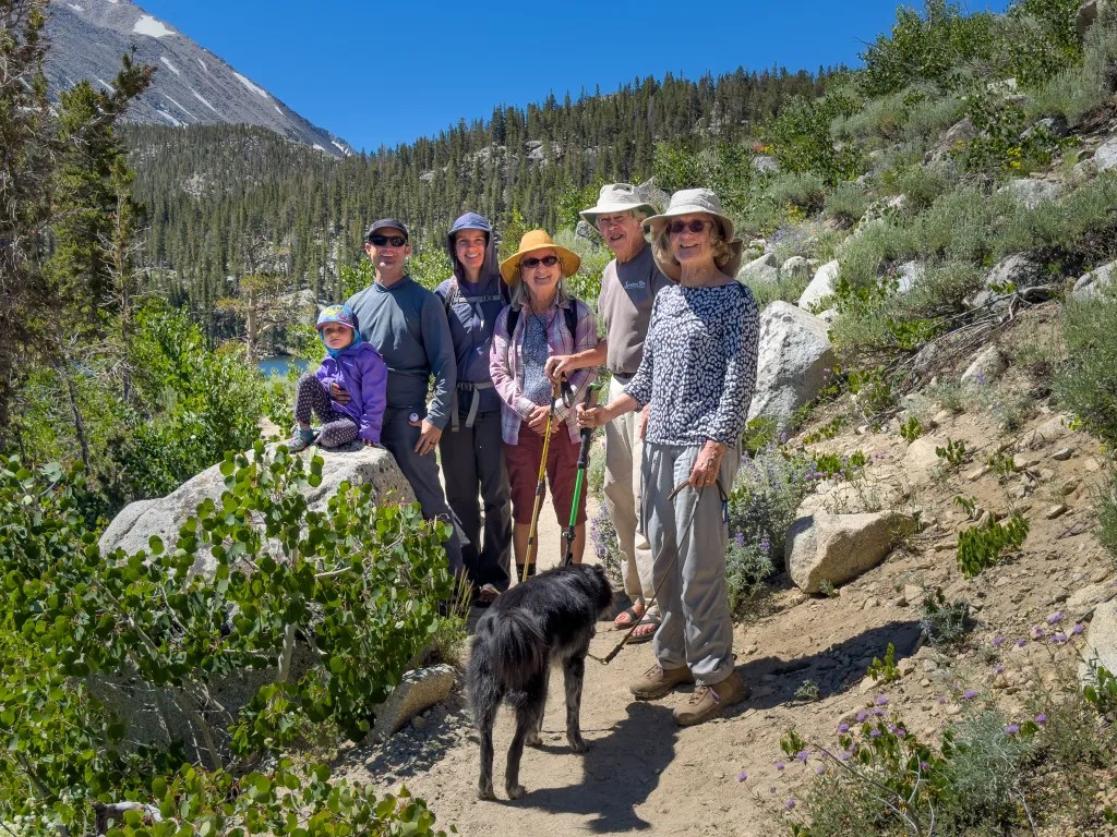
Our granddaughter’s fifth birthday was reason enough to join family at Rock Creek. So here we are at the East Fork Campground on Rock Creek in the Eastern Sierra: our granddaughter, her parents and two sets of grandparents.

We spent two nights here at 9000 feet of elevation, a cool retreat from the heat of the Owens Valley. For breakfast we fired up the Dutch Oven and cooked up a mushroom and brie breakfast strata, one of our favorite breakfast recipes. The hot coals provided heat to warm hands on the chilly morning. With two days to explore, our adventures included hiking around part of Rock Creek Lake and also paddling on the lake.

The trails were lined with wildflowers including Sulphur buckwheat, paintbrush, Lupine, penstemon and a host of other flowers.

Between us we had three boats, two canoes, and one kayak. We even managed to get our dog Carson into a canoe and were pleased to discover that he was a mellow pooch in the boat.

It’s such a lovely experience to paddle a boat on a quiet High Sierra Lake. It’s not a big lake; I logged 1.4 miles paddling around the perimeter. A peaceful and relaxing paddle. At one point we poked our boats up into the creek that feeds the lake and got a sense of white-water paddling. We were here mid-week, arriving on Wednesday and leaving on Friday, and we were surprised at how many people were here. This is a popular place for fishing, hiking and other outdoor activities. I would imagine the weekend would find the campgrounds full and parking for fishing and hiking scarce.

Ice Cream Paddle

The Lopez Island BASK (Bay Area Sea Kayakers) trip is a biennial event, with the exception of a break during the Covid pandemic. We spent a week camping at Spencer Spit Campground; over the course of the week, we did a number of day paddles. One of the traditions is to paddle over to Blakely Island for ice cream. So today is our ice cream paddle. There were 11 of us on the beach at Spencer Spit ready to launch at 9 a.m. We had clear skies and no wind, a marvelous start for the day. We paddled out to Frost Island and then set course for Bald Bluff with the intention of minimizing our time crossing the ferry route.

We kept a keen eye out for ferry and other boating traffic as we made our crossing. Once we were across, we paddled just far enough offshore to stay out of any eddies and to take advantage of the current.

We landed on the beach at the Blakely Marina at 10:30, too early for lunch but not too early for ice cream.

We took our time eating ice cream and lunch, waiting for the current to change so that we could enjoy an easy paddle back. You can see the 11 of us in the photo below. Once we were back in our boats, we poked our noses out into Peavine Pass where the current was running strong, and we made a quick turn to enter the “express” lane for a fast ride. On the return trip we held up for ferry traffic to pass with ferries going in both directions.

We were back on the beach at Spencer Point a little after 2 p.m. We logged 9.4 miles on the day’s paddle. An excellent outing with a fun group of friends.

Lopez Island: Makaye

This is day four on our Lopez Island adventure. Today we met with a few of our fellow kayak club members (BASK, Bay Area Sea Kayakers) at the Makaye Harbor Boat ramp for a paddle around the southern points of the island.

From the boat ramp we headed south and around Iceberg Point, noodling along the coast, paddling through kelp beds and poking into caves. We conintued to noodle along the coast until we got to Blackie Brady County Park.

There we landed and broke out our lunches. After lunch we were back on the water retracing our route back to our launch site.

Over the course of the day, we logged 11.6 miles on calm water with very little wind. It was a grand experience paddling along the rugged coast where one can imagine what the currents and water conditions might be like in less favorable conditions. We even saw a Bald Eagle sitting on a rock close to where we were paddling. Unfortunately, I wasn’t fast enough with my camera to capture the magnificent bird.

Rescue Practice

So here’s the scenario. You’re out paddling your kayak along with some of your buddies and one of your paddling buddies ends up unconscious floating face down in the water. And this happens under the Golden Gate Bridge in some lumpy water. What do you do?

This is one of the scenarios we acted out with members of our kayaking club, Bay Area Sea Kayakers (BASK) recently. We gathered in the morning at Horseshoe Bay, on the North side of the Golden Gate Bridge. We broke into two groups, those that wanted to practice basic rescue skills and those that wanted something more challenging, including incident management.

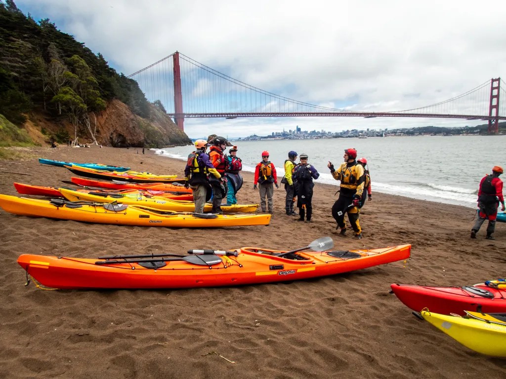
I joined the more advanced group. We launched our boats and headed out to the Golden Gate Bridge. It was just off Lime Point where we had our first execution of a T-rescue. With practice, this is an efficient and quick way to get someone back in a boat. After the morning’s practice sessions, we landed at Kirby Cove for lunch. As you can see, it was a gorgeous day to be on the water.

After lunch we were back on the water. This is where we had a more complicated scenario. Just what do you do when you have an unconscious kayaker in the water? Someone needs to go in the water to assist the person, get them face up, and perhaps provide rescue breathing. Someone else needs to get on the radio to call for help. In our practice, we did get the person back in the kayak and upright, with some cooperation from our “unconscious” victim. The kayak was now full of water and unstable, so two kayakers came alongside to stabilize the boat and the paddler. Two other kayakers used an inline two to get the swamped boat and victim to safety. We were now surfing breaking waves with white caps. I can’t say our “victim” would have survived if this was a real situation, but we all agreed that practicing this scenario gave us a better understanding of what we would do in a real situation. And messing about in boats with good friends and well-accomplished paddlers is always fun.

Bahía Concepción

Today we arrived at Playa Santipac. At the gate we paid 200 pesos for one night thinking we would move on the next day, but we ended up spending two nights. The campground was fairly busy, but we did find a suitable site with a palapa about 1/2 mile down the beach.

Playa Santipac is a popular spot for big rigs but also suitable for smaller rigs and tents. We had fun visiting with fellow campers who were walking along the beach, many of them from Canada and other northern locations that come down to Baja for several weeks or more. One of the joys of traveling is hearing people’s stories. Everybody on the road seems to be quite friendly and happy to share information.

There is no running water at the campsites, but vendors drive along the beach in the morning and provide you with a blue barrel with as much water as you wish for a small fee. There are also vendors selling fresh fish and a variety of other things. We bought water to use for washing since we wanted to conserve the water we had on board for drinking and cooking. We also bought some fresh halibut which served us for a couple of dinners as well as a hammock and some carrot cake.

We did manage to get our boats on the water, paddling out from the beach and around several islands. In one of the photos, you can see Joann in the little wooden boat with a line of RVs on the beach in the background. The beach at our campsite was quite shallow at low tide, so we ended up dragging the boats until we had enough water to paddle. If I had been paying attention, I would have given priority to a campsite further west where the beach wasn’t quite so shallow.

After a few days of dry camping, it was nice to have a shower even if it was just pouring a bucket of cold water over my head. For lunch we walked down the beach to Armando’s, a rustic shack on the beach with delicious seafood tacos.

After a couple of days at Playa Santipac we moved on to Playa Coyote. This is a popular spot. We pulled into the campground at 10:30 in the morning and found the last open site. We were surprised to discover that the campers next to us were kayakers, fellow members of BASK (Bay Area Sea Kayakers). We pooled our resources for dinner. I fired up the Dutch Oven and baked up some Halibut. In the morning we paddled together around Isle Coyote. It was a gorgeous day to be on the water and the flat calm gave us the opportunity to look below the surface. We saw many sting rays.

And talking about sting rays, I managed to step on one. Ouch! Before we launched our kayaks, I was tossing the ball for Carson and the ball went in the water. Carson wouldn’t go in the water to get it, and while the water was only six inches deep, I forgot to do the sting ray shuffle. Fortunately, I was wearing sandals and after a little first aid I was on the water paddling. I think I was quite lucky, since sting ray wounds can be very painful.

While we did have thoughts of driving further south to Loreto, Playa Coyote was such an idyllic spot we decided to spend time there rather than adding more miles to our trip.

More photos of Bahia Conception are available in an online gallery.

Ferry Point to Point Isabel

When we arrived at the parking lot at Ferry Point, we were amazed at how many of our fellow BASK members were getting ready to paddle. It looked like a record turnout for a Thursday lunch paddle. We were on the water at 10 a.m. I counted 12 boats on the water. We paddled out a short distance to the shipping channel and held up waiting for a tugboat with a barge to pass. Shortly thereafter we broke into two pods. One paddler was trying a new boat and discovered that it was not working for him. Fortunately, he was able to paddle back to the beach accompanied by several others and swapped the boat for something more stable. That left the remainder of us waiting. Using our radios to communicate, one pod opted to continue on. The second pod would follow.

We paddled around the end of the breakwater and headed for Brooks Island. On the way we noticed flocks of Cormorants flying about. I don’t recall seeing Cormorants in such numbers. With calm water and no wind, we had an easy paddle. We landed at the Point Isabel boat ramp at 11:40 and with the low tide we had plenty of exposed beach. The second pod was not far behind. They landed about the time we got our boats up above the tide line.

When we arrived on the beach, we were delighted to be greeted by one of our members who had arrived by car, taking a break from paddling due to a back issue. Given the fact that many of us are past 70, I’m about to turn 73, it’s amazing that we can get on the water as often as we do. I keep telling myself to go paddling when I can. My paddling days are numbered. In the morning I will find myself questioning whether I’m up for paddling, given various aches and pains and the desire to just take it easy. But after a paddle I feel ten years younger. I consider paddling part of my physical and mental health regime.

After lunch we were back on the water, taking the inside route back to Ferry Point, landing on the beach about 2:30. Our day’s paddle covered 8 miles.

More photos are available in an online gallery.

Gone Paddling x 4

Here are four more paddling adventure which deserve to be documented. I consider this blog to be a diary of my adventures. If I don’t record the adventures, I may forget they ever happened. And for the past few years, as the new year turns over, I have turned my blog entries into a coffee table book.

So here are four paddles: 10/27 Richmond to Albany, 11/03 Eckley Pier, 11/10 Gallenas Creek, and 11/28 Windsurfer.


Richmond to Albany

On October 27 there were just two of us with two wooden Pygmy Boats. We launched from Ferry Point in Richmond, paddled out past the end of the breakwater and then past Brooks Island. We poked into the basin northeast of Caesar Chavez Park thinking we might find a spot to land, but we didn’t see much so we paddled to Albany Beach where we stopped for lunch.

After lunch we returned to our launch site by way of the Richmond waterfront, stopping to admire the Red Oak Victory. We logged 11 miles.

More photos are available in an online gallery.


Eckley Pier

November 3. Seven of us gathered at Eckley Pier for a paddle to Martinez. The pilings of several abandoned piers provide an obstacle course to practice boat control. I had my GoPro camera running to capture the action. It remains to be seen when that footage will be available. From Eckley Pier we paddled out towards the shipping channel to take advantage of the flooding current.

Once we reached the Martinez Marina, we hauled our boats up the boat ramp and off to the side to keep the ramp free for boaters. We logged 8.8 miles over the course of the day.


Gallenas Creek

November 10. Up the creek, Gallenas Creek. We launched from China Camp and took advantage of the high tide to paddle up the creek. When we could no longer make forward progress, we returned to the McInnis Canoe and Kayak Dock where we hauled out our boats and had lunch. Our course covered 10 miles.

More photos are available in an online gallery.


Windsurfer Beach

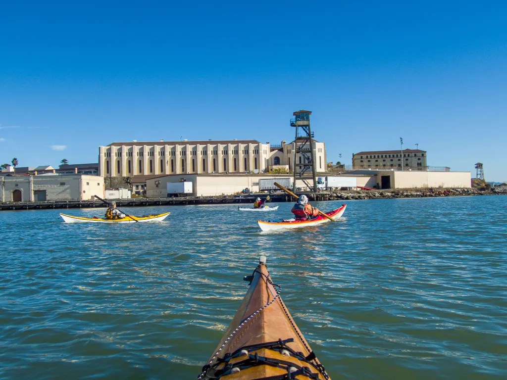
November 29. Loch Lomond to Windsurfer Beach. This paddle takes us under the Richmond San Rafael Bridge and past San Quentin State Prison. At lunch on Windsurfer Beach, we watched the ferries and a dredge. We paddled around the Marin Islands on the return leg, a total of 8.2 miles.

More photos are available in an online gallery.

Angel Island

Thursday morning, November 17. A chilly morning, and climbing into my wet, clammy dry suit seemed quite rude. Wet inside and out. I had been out the previous evening for a rolling clinic. The suit was wet on the outside from being upside down in the cold water of San Francisco Bay, and damp on the inside from condensation. I contemplated adding a layer of insulation but figured once I was on the water I would warm up.

Six of us assembled on the beach at Ferry Point. The predicted weather and tides were favorable for a paddle around Angel Island. After a quick safety talk and radio check we were on the water at 10 a.m. Shortly after leaving the protection of the Richmond Shipping Channel, we encountered a breeze and some wind waves out of the northwest. We watched several ferries zipping up and down the bay, and then we held up for a barge that was crossing our path in the shipping lane. We had a couple of harbor seals check us out also.

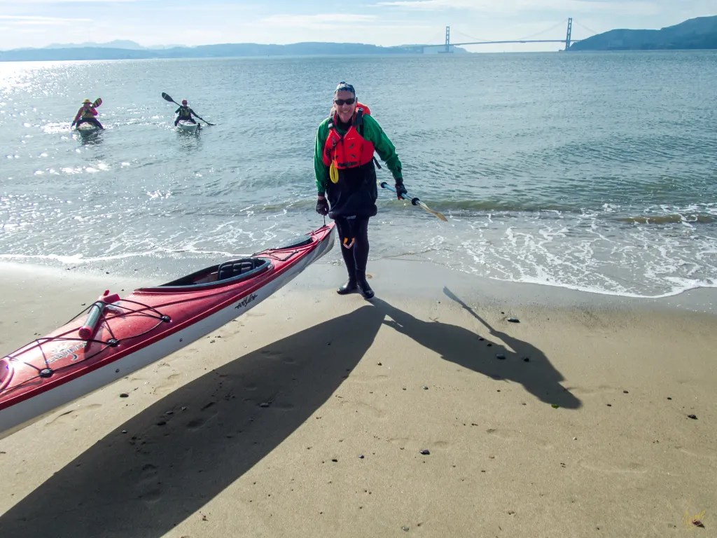
Our radios were handy for staying in touch and keeping the pod together in the midst of ship traffic. Once we were across the shipping lane we opted to continue our way around the island in a clockwise direction. We landed on Perles Beach a little after noon. Perles Beach faces the Golden Gate with a panoramic view that includes San Francisco as well.

There was just enough breeze to create a bit of a wind chill, so after a brief lunch we were happy to get back in our boats to continue our journey. Back on the water we continued around the island. After rounding Point Stewart, we paddled close to shore to check out the beach at Kayak Camp. One of the photos shows a fellow kayaker with his boat pointed to the trail that leads up from the beach to the campground. There was no trail visible from the water. The trail is presumably overgrown. Once we were back around to the eastern side of the island, we again held up for shipping traffic and then continued on our way back to Ferry Point.

We were back on the beach at 2:20 p.m. after a perfect paddle around Angel Island logging 12 miles. You can see more photos in an online gallery. Here’s the track of our paddle.

Pt San Pablo to Pt Pinole

On October 13, seven of us were on the beach at Point San Pablo Harbor ready to launch. Weather and tide conditions were promising for a paddle to Point Pinole with little wind predicted. Slack tide at 9:47 a.m. at Pinole Point meant we would have the current with us in the morning. We launched at 10:30 and headed out towards the shipping channel to pick up the current. As we paddled, we kept our eyes open for ships and ferries.

We had some ship traffic and noted that one of the ferries heading towards us did an about-turn. What was that about? It seemed like several of the ferries were exhibiting some unusual behavior.

When we reached Point Pinole, we decided to paddle around the point landing at the beach on the northeast side. It was shortly before noon when we landed. The beach has a handicap accessible ramp. After lunch it was back on the water, and we used the pilings of the old pier as an obstacle course. Good for practicing boat control.

Since we were still experiencing the incoming flood, we planned paddled closer to shore to take advantage of countercurrent eddies. We were back at our launch site shortly before 3 p.m. having logged 10 miles. More photos are available in an online gallery.