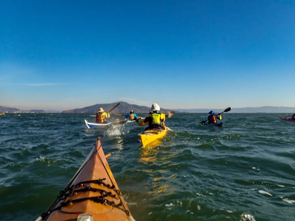
Ferry Point to Point Isabel

When we arrived at the parking lot at Ferry Point, we were amazed at how many of our fellow BASK members were getting ready to paddle. It looked like a record turnout for a Thursday lunch paddle. We were on the water at 10 a.m. I counted 12 boats on the water. We paddled out a short distance to the shipping channel and held up waiting for a tugboat with a barge to pass. Shortly thereafter we broke into two pods. One paddler was trying a new boat and discovered that it was not working for him. Fortunately, he was able to paddle back to the beach accompanied by several others and swapped the boat for something more stable. That left the remainder of us waiting. Using our radios to communicate, one pod opted to continue on. The second pod would follow.

We paddled around the end of the breakwater and headed for Brooks Island. On the way we noticed flocks of Cormorants flying about. I don’t recall seeing Cormorants in such numbers. With calm water and no wind, we had an easy paddle. We landed at the Point Isabel boat ramp at 11:40 and with the low tide we had plenty of exposed beach. The second pod was not far behind. They landed about the time we got our boats up above the tide line.

When we arrived on the beach, we were delighted to be greeted by one of our members who had arrived by car, taking a break from paddling due to a back issue. Given the fact that many of us are past 70, I’m about to turn 73, it’s amazing that we can get on the water as often as we do. I keep telling myself to go paddling when I can. My paddling days are numbered. In the morning I will find myself questioning whether I’m up for paddling, given various aches and pains and the desire to just take it easy. But after a paddle I feel ten years younger. I consider paddling part of my physical and mental health regime.

After lunch we were back on the water, taking the inside route back to Ferry Point, landing on the beach about 2:30. Our day’s paddle covered 8 miles.

More photos are available in an online gallery.

Roof Rack Failure & Windsurfer

Sometimes it seems the hardest part about kayaking is getting the boat to the water. Getting the boat on the car and getting it off the car and to the water at the launch site can be a challenge. Today I had an added challenge. As I tugged on one of the straps to cinch the boat into the saddles on the car top carrier the cross bar came loose. On inspection I discovered that the support tower that secures the crossbar to the roof was broken. It would be easy enough to just pack it in, but a little voice in my head was saying, “Treve, if you really want to go paddling you have another vehicle you can use.” The racks for the truck were sitting in the driveway, so I accepted the challenge of seeing if I could get the kayak on the truck in time to make it to the launch site. Our intended launch time was 10:00. Google Maps was telling me that it was a 21-minute drive which meant I might just make it. Sure enough, I was able to get the kayak on the camper and on the road in a timely fashion. It was 10:03 when the six of us pushed off from the beach.

With the constant parade of storms coming our way we found a weather window with perfect conditions for paddling. Our course took us past San Quentin State Prison, then under the Richmond San Rafael Bridge and on to Loch Lomond Marina. Just for fun we tried squeezing our boats through a narrow gap in the pilings at the end of the breakwater at the Yacht Harbor.

Time for lunch, but in my haste to get on the road after the roof top debacle I did not have time to make a lunch. Andy’s Market has a fine selection of deli foods and a bowl of Italian Wedding Soup, and a loaf of Judy’s bread hit the spot. And don’t forget the chocolate that seems to be ubiquitous on our paddles.

On our return paddle we had calm water and building clouds. We paddled out around the Marin Islands and then back to our launch site, and of course ferry traffic since Windsurfer Beach is close to the Larkspur Ferry Terminal.

My story starts with car top racks, so it’s only appropriate to end with a photo of my boat on top of my camper after the paddle. We covered 8.5 miles over the course of our paddle. Here’s a map that shows our track.

More photos are available in an online gallery.

Pt San Pablo to Pt Pinole

On October 13, seven of us were on the beach at Point San Pablo Harbor ready to launch. Weather and tide conditions were promising for a paddle to Point Pinole with little wind predicted. Slack tide at 9:47 a.m. at Pinole Point meant we would have the current with us in the morning. We launched at 10:30 and headed out towards the shipping channel to pick up the current. As we paddled, we kept our eyes open for ships and ferries.

We had some ship traffic and noted that one of the ferries heading towards us did an about-turn. What was that about? It seemed like several of the ferries were exhibiting some unusual behavior.

When we reached Point Pinole, we decided to paddle around the point landing at the beach on the northeast side. It was shortly before noon when we landed. The beach has a handicap accessible ramp. After lunch it was back on the water, and we used the pilings of the old pier as an obstacle course. Good for practicing boat control.

Since we were still experiencing the incoming flood, we planned paddled closer to shore to take advantage of countercurrent eddies. We were back at our launch site shortly before 3 p.m. having logged 10 miles. More photos are available in an online gallery.

Breaking the Curse

For the past six weeks or so we’ve been cursed with contrary winds. It seems we’d plan a paddle and the wind we experience was not what was predicted. It seemed as if the wind gods were playing havoc with us. We’ve been attributing this curse to Alan, one of our paddling buddies, since he was the one that was planning the paddles. We even devised a plan where we would send Alan off in one direction hoping he would serve as a decoy so the rest of us could paddle on calm water.

But on Thursday afternoon July 7, following a lovely paddle, we gathered at the Up and Under Pub where we shared a toast and declared the that we had broken the curse.

Six of us launched from Ferry Point that morning for a paddle around Brooks Island. We paddled in the counterclockwise direction, crossing the open water early in the event that the wind should come up later in the day.

Paddling along the south side of the jetty we encountered quite a bit of eel grass. We had this experience on a previous paddle at this location and it seems this year there is eel grass where we don’t recall seeing it in the past. Then, having spied the remains of the dead whale, we paddled close to take a look. Jaw bones are now exposed where a month ago it looked like a freshly beached whale.

We were also amazed at the number of pelicans we saw, wheeling overhead, diving and fishing. We stopped at Barbara and Jay Vincent Park for lunch, walking to the top of a knoll where we found some rocks on which to sit.

After lunch it was back on the water. The wind had picked up a bit and we were bracing for a slog into the wind. We crossed the channel heading to Brooks Island and admired an Osprey that was feeding its young in a nest on top of the dolphin (pilings) in mid-channel. Then the wind eased up and we had a pleasant paddle back to our launch side, again mystified with the number of pelicans that were about. You can see more photos in an online gallery.

Gone Paddling

I can’t seem to keep up with my own adventures. To get current, here are three kayak trips I’d like to share: February 4 from Point San Pablo Yacht Harbor, March 17 Windsurfer to Loch Lomond, and March 22 Loch Lomond to some islands.

Point San Pablo Yacht Harbor

On February 4, five of us launched Point San Pablo Yacht Harbor. The idea was to cover some miles as training for a club event we call the Gonzo, an endurance paddle that visits 15 islands in the Bay. Depending on the route you take, this can be 40 miles. No way am I going to paddle that distance, but I did want to stretch my endurance a bit so I joined this training paddle. Our plan was to paddle between The Brothers, then to an island near the San Rafael Bridge which will remain unnamed, then between the Marin Islands, through The Sisters and back. Our plans changed a bit after we reached the Marin Islands. It became clear that going for The Sisters would put us at a strong disadvantage with the current and wind to make it back to our launch. Just getting back to The Brothers took some effort as the current was starting to build. We managed to cover 9.8 miles with a moving speed of 3.8 mph. Check out more photos in my online gallery.

Windsurfer to Loch Lomond

On March 17 five of us launched from Windsurfer Beach. Our original plan was to paddle on Tomales Bay, but the predicted wind did not bode well for that paddle. My wife and I got an early start with the plan to beat the traffic across the Richmond San Rafael Bridge with a stop at the Bovine Bakery for breakfast. We were already on the road when the call was made to cancel the original plan. With a few quick phone calls, we were able to formulate a plan “B” to launch from Windsurfer Beach. No Bovine Bakery, but we did find Rustic Bakery which also has a delectable selection of goods, so that suited us for breakfast. We logged a healthy 8.3 miles with a moving speed of 3.2 mph. Check out more photos in my online gallery.

Loch Lomond and Islands

On March 22 eight of us gathered at Loch Lomond Marina for a paddle around several islands. Since our route included crossing shipping channels and dealing with currents, we had a briefing to discuss the route. Once on the water we paddled out to the Marin Islands. We found some very shallow water on the way to the islands, barely six inches of water in places. If the tide had been any lower we would not have been able to paddle this route. From the Marin Islands we headed to the island near the San Rafael Bridge that will remain unnamed, and from there it was back to our launch point. We logged 8.9 miles with a moving speed of 3.4 mph. Check out more photos in my online gallery.

Point San Pablo to Bullhead Flat

On the morning of March 1, six of us gathered at the beach at Point San Pablo Yacht Harbor with a plan to paddle across the bay to Bullhead Flat, a destination in China Camp State Park. Since currents, wind and shipping traffic are concerns, we spent some time discussing the plan before launching our boats. With a slight flood we expected the current to push us north, up the bay, so we set a ferry angle taking us more directly across the shipping channel with the current carrying us towards our destination.

We were on the water at 10 a.m. David turned his radio to channel 14 to notify Vessel Traffic Control (VTC) that a pod of six kayakers would be crossing the shipping channel. He was not able to raise VTC. We paddled on until we were outside of Point San Pablo where I was able to contact VTC on my radio. I reported our location, our destination, and the estimated time for our arrival across the shipping lanes. The red buoy marks the starboard (right) side of the shipping lane.

Once across we headed for The Sisters, a couple of islands off of Point San Pedro. Several of us decided to “thread Grendel’s Needle,” a gap in the rocks on the westernmost Sister. We had calm water paddling through the needle. With a stronger current and wind, there can be quite a surge of water.

We were a bit hesitant to paddle the needle since there was a flock of cormorants on top of the island, and we try our best to not disturb the birds when we are paddling. From The Sisters, we paddled north past McNears Beach, past the China Camp Village beach, and on to Bullhead Flat. There we pulled our boats out of the water and found a picnic table to use as we broke out our lunches.

After lunch, it was back on the water for the return trip. The current was now ebbing a bit, so we had the current working with us as we crossed the bay. Again, we set a ferry angle to compensate for the current. The gathering clouds caught my attention on the return paddle, and I thought they made for a lovely photo composition with the kayaks. I’ve posted an online gallery with more photos. You can see a track of our paddle below. We logged 8.3 miles for a very pleasant day on the bay

Starting the Year with a Splash

On January 2, I was on the water with fellow BASK members (Bay Area Sea Kayakers) for a paddle around Angel Island. Eleven of us assembled at Horseshoe Bay near the north end of the Golden Gate Bridge. After a brief safety talk and radio check, we were on the water at 10 a.m. We were looking to take advantage of the strong currents associated with the king tide. Our plan was to head south into the shipping channel to pick up the “express lane,” the flooding current for a ride to the island.

Paddling into the bay, we crossed a well-defined eddy line, the line separating the still water from the fast-moving current. Once we were onboard, it was a smooth ride to the island. We poked around the rocks near Point Blunt and landed at China Cove for lunch, hauling our boats up off what little beach was left to keep them secure from the rising tide.

After lunch we were back on the water. With a high tide of 7.4 feet, an afternoon low tide of -1.9 feet, and slack water at 12:40 p.m., we were looking for a fast ride back through Raccoon Strait. What we didn’t expect was some rough and turbulent water at the west end of Ayala Cove. We encountered a tide race just off the point with whirlpools, eddies and chaotic waves. The chaos resulted in collisions, capsizes, lost paddles and hats, and a bloody head wound. Four of our paddlers ended up in the water. Mind you these are experienced paddlers. While we were facilitating rescues, a few harbor porpoise were cavorting about.

I’m not sure how I managed to stay in my boat in the chaos. Crossing the turbulent water was like being in a washing machine. No chance for photos here. My hands were busy bracing with the paddle. I did capture a photo of one of our paddlers being assisted getting back in his boat. With everybody back in their boats, we made a quick stop on the island for first aid. Then it was time to finish our return trip.

A few of us rode through the tide rip at Yellow Bluff and made our way back to our launch; another pod stayed clear of the rip, riding the express lane in the deeper water before turning into Horseshoe Bay.

You can see more photos in my online gallery. Over the course of the paddle we logged 10.6 miles with an average speed of 3.6 mph. Here’s the track of our paddle.

Angel Island 03/02/21

March 2, 2021. After returning from my desert sojourn visiting family and exploring the Eastern Sierra, it was time to get back on the water. This paddle took us from Ferry Point in Richmond and out around Angel Island with a stop at the West Garrison for brunch. We then continued around the island and back to our launch site.

A side note here about WordPress. I’ve had reports from those that subscribe and get the email version that the photos are distorted in the email, so I’m experimenting with different gallery settings. The photos above are presented in a Tiled Gallery format. Those below use the straight Gallery format. Please let me know if one of these formats works better.

West Garrison is on the west side of the island facing the Golden Gate Bridge. It was originally called Camp Reynolds, which was established in 1863 as concerns mounted over threats to the Bay Area from Confederate sympathizers and naval forces.

We were on the water at 8:30 a.m. which is early for us. We wanted to take advantage of the tides and currents. Our plan was to paddle to Ayala Cove for a stop but when we got to the West Garrison the water was flat calm and the beach looked inviting so we stopped and pulled out our snacks. You can see our boats on the beach with some pilings and the Golden Gate Bridge in the background. We were again on the water at 11:00 and back at our launch site shortly after noon, logging 11 miles and paddling on placid waters for the whole trip. Our trip leader, Jenn, looked quite spiffy in her new boat, black with a sparkling metal-flake finish, yellow trim and deck lines, and matching outfit. I’ve posted additional photos including some artistic representations of a couple of images. Click here to view.

Here’s the track of our paddle.

I’ve posted a number of blog entries about paddling to Angel Island. You can find additional posts by searching for “Angel Island” in the search box.

Surfing Ashby Shoal

January 7. Our intent was to enjoy a quiet paddle from Barbara and Jay Vincent Park in Richmond to Emeryville and back. We were on the water at 10:20 with an ebbing tide. It was a calm day with very little wind and no wave action. As we approached Emeryville, though, we could see waves breaking on Ashby Shoal.

We decided to go check it out. Once we got there we decided to play in the surf. I didn’t have much luck riding the waves. I just couldn’t get the momentum to get a good ride, but I did get in some bracing practice as the boat broached. One of our gang ended up out of his boat, and we proved that the T-rescue is an efficient way to get somebody back in the boat.

Part of our group stayed out of the surf zone, and we had a lesson in radio communication. Susan called Steve to find out what was going on. Steve was with me, standing by while I assisted Alan. Steve’s radio was off. He heard the call coming on my radio and tried to respond thinking his radio was on. I was busy helping Alan get back in his boat. Susan’s radio went dead before we were able to respond. The lesson here is to keep your radio charged and remember to turn it on if you want to communicate. After we got Alan back in his boat, it was a quick paddle into the Emeryville boat ramp where we found a little park for a socially distanced lunch.

After lunch it was back on the water for our paddle back to Richmond, with a short stop while Sharon pulled out her bird guide to identify birds. We logged 11.4 miles over the course of the paddle. More photos are available here.

Around Angel Island

We gave a fitting send off to the year 2020 by putting our boats in the water and paddling around Angel Island on the last day of the year. The quality of light, the serene conditions and the reflections on the water prompted me to convert the images to black and white.

Four of us launched from Dunphy Park in Saualito, pushing off at 10:20, about the time for maximum flood. We paddled out to Point Knox and around the island counter-clockwise. We did feel a bit of the current as we approached Point Knox, with the current trying to push us up Racoon Strait. Once around the point though we had the current going with us and we made good time going around the island and landing at the Immigration Station.

We had a suitably social distance lunch while sitting on the ledges that were part of the historical display. You’ll note that one of our paddling buddies, Steve ended up half-way between “Acceptance” and “Rejection” in the “Realities” zone.

After lunch the current was beginning to ebb, so we had the current with us for an easy paddle down Racoon Strait. As we rounded Peninsula Point, back into Richardson Bay we hugged the shore admiring the expensive home on Belvedere Island. I was looking up at the homes on the cliff when with a crunch I found myself aground on a rock. Easy enough to get back on track, but a reminder to keep an eye on the water. Then it was across the bay back to our launch site, after some discussion about what landmark to aim for. Navigation from a low vantage point can be a challenge . We were back on the beach at 2:15, but only after breaking a paddle while landing. When getting out of the boat, I discovered that I was in a rocky hole, not a firm beach. I put my paddle down for balance, inadvertently wedging it between two rocks. Down I went and leaning on the paddle caused the shaft to snap.

So it goes. I’ve had a paddle on my shopping list for some time. Now I have an excuse to buy one. We logged 9.5 miles and I don’t recall ever having such an easy and pleasant paddle around the island. It was a very quiet day on the bay. Calm weather, and not much boat traffic. We did see a number of the usual bay residents including cormorants, gulls, pelicans and harbor seals. You can view more photos here, including both the black and white and color versions of the images above. Let me know what you think.

%d bloggers like this: