Back to Oban

Day 16 of our Scotland Trip. Our plan was to spend the better part of this week at the Iona Abbey as part of the Iona Community. Circumstances have forced us to change our plans. Joann and I both tested positive for COVID-19 a few days ago. At the time we had booked two nights at the Pennygate Lodge in Craignure. We were able to extend our stay to four nights which was fortunate. The hotel has a excellent restaurant, and we were able to hold up in our room with excellent food delivered. Despite our current situation we have had some amazing adventures in the past two weeks. The highlight was kayaking around Iona with Wilderness Scotland. That adventure warrants a blog posting of its own.

So today we left the Pennygate and took the ferry back to Oban. We’ve booked an apartment for several nights. I’m looking forward to using some of the downtime to work through some of the photos and videos and to post more about the trip. While at Pennygate I was sick in bed with no energy to do anything more that sleep and read. The Seabreeze Apartment where we are now feels almost liberating with two bedrooms, living room, and kitchen. Plenty of room for two people to roam around while we rest and recover.

On our previous stay in Oban we celebrated our 49th wedding anniversary. I also spent one evening wandering around town looking for nighttime photo opportunities.

Stay tuned. I have more stories to share.

Golden Rose Ranch

On July 18 we found our way to Golden Rose Ranch where we spent the night in some beautiful red rock country. This was another camping find we discovered through Hipcamp. Definitely off the beaten track. Dry camping with no facilities which suits us just fine.

There are three campsites on the ranch but we had the place to ourselves. In the evening the cliffs catch the late afternoon light, which was cause to bring out my big camera (the Nikon D850) and tripod to capture some long exposures. In the morning we broke camp and spent some time exploring the petroglyphs and wildflowers. Golden Rose Ranch was a delightful overnight stop on our return from New Mexico.

The Turquoise Trail

On July 17 our route took us through Taos, where we stopped at Ranchos de Taos to see the San Francisco de Asis Catholic Mission Church; always a notable stop with the abode buttresses and surrounding architecture providing plenty of photo opportunities in both color and black and white.

Then we passed through Santa Fe, making a brief stop for ice cream. Consulting the map we noticed an alternate route, so rather than blasting through on I25 we headed for Highway 14, also known as the Turquoise Trail. The drive took us through several small towns. We stopped Los Cerrillos, where we explored the grounds of the church and some of the colorful buildings around town. The town was very quiet during our visit, but it was clear that a number of art galleries and artists would make this a busy spot when tourists are out.

We had to do a double take as we passed a herd of colorful origami horses. Having driven past, we made do a U-turn to take a closer look; something that’s not uncommon, and one of the reasons we like the less travelled routes. I wouldn’t even think about doubling back if we were on a four-lane divided highway. The Outside the Box Studio was closed, but we had a clear view to look over the barbed wire fence.

Continuing on we were struck by a small church near Golden, and again stopped to take a few photos.

Then it was back on the main highway, I25, to make our way through Albuquerque and on to our campsite at The Golden Rose Ranch near Prewitt, New Mexico.

On to Angel Fire

On the afternoon of July 13 we arrived in Mancos, where we spent the night camping in Kayla’s driveway. We stopped at a liquor store in Mancos to get a bottle of wine to share with dinner. I had to capture a photo of this mural on the side of the liquor store. Kaya is a professional cook and dinner was scrumptious. Here’s a photo of Kayla harvesting some greens for dinner. You can see our camper in the background. Then it was on to Angel Fire. Our drive took us through Durango, Pagosa Springs, Chama and on to Angel Fire. Check out the Stick Library for dog lovers in Pagosa Springs.

In Angel Fire we spent three nights at the Enchanted Circle Campground. The campsite was on a secluded knoll at a private ranch. Joann found this camp through Hipcamp. Given the wide-open space I decided to put the drone in the air to capture a view of our campsite. The site was perfect for our needs, quiet, secluded, and with open skies. One evening a few of the ranch horses decided to check out what was cooking.

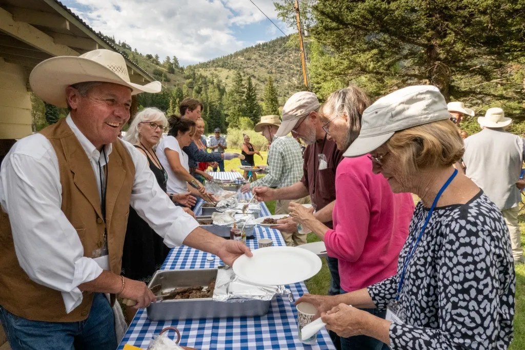
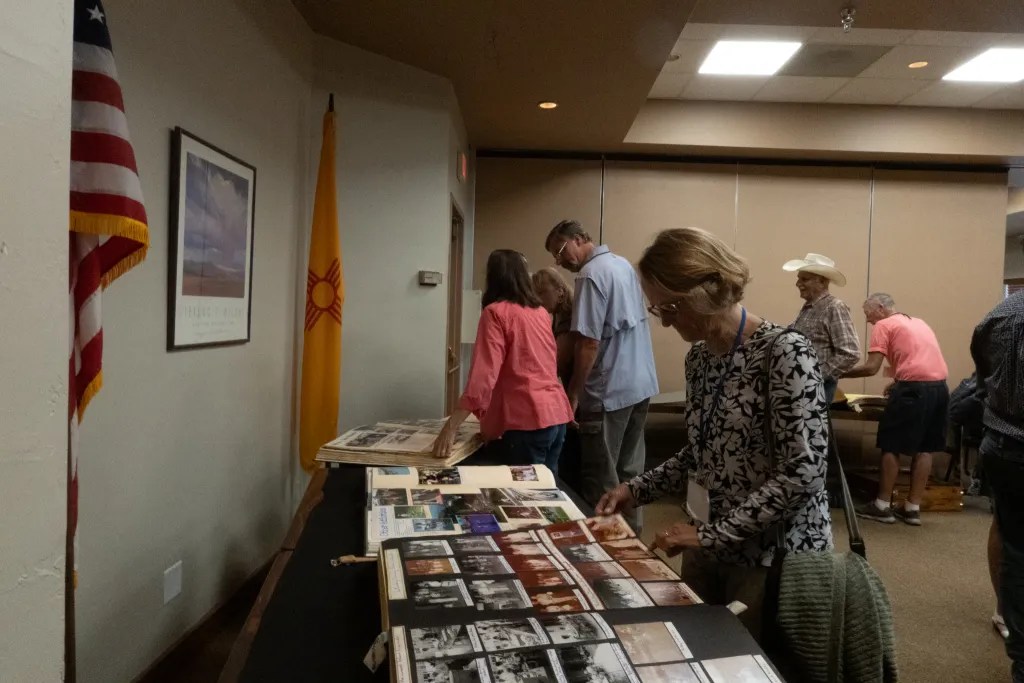
Of course, our reason for being in Angel Fire was to attend the Sundt Family Reunion. Reunion activities included a picnic dinner on the C & S Cattle Company Ranch, a 130,000-acre spread, and browsing through family scrap books. The family is divided up into 12 “tribes” with each tribe having its own scrapbook. The tribes represent the children of MM Sundt. We had 110 people including 3 family members from Norway. As you can see, the scrapbooks are huge and chock full of photos and memorabilia. So much fun to browse through.

Many of the family members are ranchers and, being cowboys, they know how to spin a yarn. The family dinner was not shy for storytellers, with various brothers, uncles, and nephews correcting each other and embellishing the stories. There’s even a bear story where it took 40 years for the campers that were spooked by a bear to learn that it wasn’t a real bear. You can see more photos in an online gallery.

Ruby Mountains

Continuing on our road trip to New Mexico, on the afternoon of July 10 we left Highway 80 near Elko Nevada and drove 35 miles up into the Ruby Mountains. Our campsite at Thomas Canyon Campground was situated at an elevation of 7,600 feet. While most of the drive across Nevada is arid desert, Thomas Canyon is in a lush grove of aspen surrounded by wildflowers. We spent two nights here, giving us one day to take a delightful hike up the canyon.

We were happy to find that fires were permitted and we bought firewood from the camp host. These days one isn’t guaranteed a campfire, given dry conditions with high fire risk. The next morning we fired up the Dutch oven for a breakfast of hash brown crusted quiche. A delicious breakfast before we set off on our hike. The hike goes 2.25 miles up the canyon, so up and back we logged 4.5 miles.

The hike climbs from about 7,600 feet to 8,900 feet through aspen groves and meadows of wildflowers, following Thomas Creek for much of the way. Here’s the track of our hike.

In the evening I took my big camera out and grabbed my tripod to see what I could find in the late afternoon light. Lo and behold I found a sunlit grove of trees that looked like fall color in the last rays of light. Some of these image will be in my art store shortly. You can view more photos in an online gallery.

Tomales: Marconi to Chicken Ranch

On June 26, seven of us launched our kayaks from Marconi Beach not knowing quite where we’d end up for lunch. Shortly after 9 a.m. we launched on flat calm water, paddling across to Hearts Desire Beach where one of our fellow BASK members was assisting at an Environmental Traveling Companions kayaking event.

From Hearts Desire we noodled southeast along the Point Reyes Peninsula, taking our time and exploring all the nooks and crannies and even some caves. Paddling through eel grass beds we saw hundreds of jelly fish. Since my Olympus TG5 camera is waterproof I popped it under the surface and started snapping pictures more or less at random. I was amazed I got something useable.

Paddling on, before you know it we were at Chicken Ranch Beach. It was just a few minutes after 11 a.m. and, though it was early, we decided it was lunch time. Our plan was to get an early start and get off the water before the wind came up.

Sure enough, as we were eating lunch the wind started to build and not as predicted. The prediction was for WSW winds 9 kts. What we had was coming straight down the bay. We launched into a stiff wind that was raising whitecaps. Fortunately, we did not have a great distance to travel so we slogged it out powering straight into the wind. We were back at our launch point at 12:30, having logged 5.8 miles. You can view more photos in an online gallery.

A Week at Loon Lake

Nestled high in the Sierra Nevada Mountains at 6,400 feet is a gorgeous lake, Loon Lake. Crystal clear water surrounded by forests, granite boulders, and patches of wildflowers. Twenty-eight miles up a windy road takes you off the main highway deep into the Sierra Nevada mountains not far from the Desolation Wilderness. We anticipated meeting a number of fellow kayakers, members of Bay Area Sea Kayakers (BASK), for a week of paddling, hiking, wildflower hunting, birdwatching, and camaraderie.

We arrived on Sunday evening, June 12, dropping off our boats near the boat ramp and finding campsite 44. We parked, popped the top up on the camper and joined one of our camp buddies, Eoin, who was preparing dinner for our cook group. The next morning, I put my drone in the air to capture a photo of our campsite.

June 13 – Rubicon Trail Hike

Monday we opted to explore the north end of the lake on foot, driving to the Rubicon Trail Staging Area and making our way partly around the lake. The Rubicon Trail is widely recognized as the premiere OHV route in the United States. As hikers, we decided to stay off the jeep trail and try to find a route that was hiker friendly. We ended up off-trail, making our way over bare rock, through thickets of trees and down through a bog. It was spectacular country but slow going as we bushwhacked. After a couple of hours, we managed to cover 2.5 miles.

June 14 – Paddle – North End of Lake

Tuesday morning we were up early to fire up the Dutch Oven and cook a breakfast of mushroom and brie breakfast strada, one of our favorite camping breakfasts. With breakfast out of the way we assembled at the boat ramp. Our route took us along the eastern shore of the lake, noodling along and poking into coves and inlets, passing a small waterfall at one point. We stopped at Pleasant Campground for lunch and then continued exploring the north end of the lake.

With the wind starting to build in the afternoon, we decided to make our way back to our launch point. We covered 10 miles in the five and half hours of our adventure.

June 15 – Paddle – South End of Lake

Having explored much of the north end of the lake, today we explored some of the islands at the south end of the lake, making our way north to a lovely lunch spot on a granite spit. We had fun doing some flatwater rock gardening in a group of rocks. I even managed to get the drone in the air to capture some aerial views, something that I’ve wanted to do for some time, but usually the logistics of paddling take priority over the logistics of flying a drone.

Again, the wind came up after lunch and we made haste back to camp, hugging the shore to avoid the brunt of the wind. We logged 6.9 miles over the course of our paddle.

June 16 – Loon Lake Trail

With two days of paddling behind us it was time for a hike. Our dog Carson had two days in the camper and it was time to give him some off-leash time. We followed the Loon Lake Trail along the east side of the lake, paralleling the route we had paddled two days before. This hike took us through some lovely forests, through glens of freshly sprouted bracken fern, over sections of bare granite rock with occasional views of the lake.

We stopped for lunch just shy of Pleasant Campground on a slab of granite with a view of the lake. There we watched the white caps on the lake and were glad we had done our paddling earlier in the week. We admired many wildflowers along the trail and covered 7.3 miles.

Please view more photos of the trip in an online gallery.

Whale on Brooks Island

May 31. Five of us launched our kayaks from the beach at Ferry Point for a paddle around Brooks Island. We were on the water at 10 a.m. after a quick safety talk and radio check. Our course took us from the beach to the end of the jetty at the end of the Richmond Shipping Channel. The plan was to negotiate the exposed leg of the paddle early before the wind and associated waves started to build. Once we were out of the shipping channel, we followed the jetty heading southeast. We were amazed by how much sea grass we encountered. Perhaps my previous experience was with higher tides and rougher water when the seagrass wasn’t so evident.

About halfway along the jetty we found a dead whale. This was cause to take photos, but to do so I had to ask one of my paddling buddies to open my back hatch get out my spare parts kit with spare batteries for my camera. My camera battery went dead shortly after launching. The island is off limits due to nesting birds, so we stayed in our boats.

With the whale well documented we continued on. Pelicans were quite plentiful, wheeling overhead and diving for fish. One pelican dove just a few feet away from my boat giving me the opportunity to capture a few photos at close range.

The water was starting to get a bit bouncy as we approached the southeast corner of the island, but nothing of concern. We landed at Barbara and Jay Vincent Park on the little beach facing the bay. The beach was a bit rocky with the low tide. After lunch we were back in our boats facing a stiff wind coming from the southwest. We decided to paddle straight into the wind which would place us on the leeward side of the jetty, hoping the jetty would provide us some protection. We battled the wind and the whitecaps and eventually found some relief.

Along the way we encountered the Brooks Island caretaker with what looked to be a load of recycling. He advised us not to land on the island due to the birds that were nesting. He also told us that one could land on designated areas from September through March when the birds are not nesting. We reported the dead whale, and continued on our journey. We were back on the beach where we had launched at 1:30 p.m. having logged 6.7 miles. You can view more photos in an online gallery.

Tassajara Ridge

Photos I had seen of some yellow lupine on Tassajara Ridge prompted us to go on a search. On the morning of April 5, we climbed in the car and drove to San Ramon. We were hoping to get an early start and find a bakery with some delectable baked goods. We ended up at a Starbucks which, while lacking the amazing fresh baked muffins where were hoping for, did suit our needs. Then it was off to find the trailhead. Our navigation seemed to be off a bit, and we discovered that access to the open space is limited. It was about 9:30 a.m. when we finally parked at the Tassajara Ridge Staging Area. This is a dog-friendly hike with dogs on leash. The hike goes through grazing areas, and we did pass a few cows on the trail.

The trail meanders along rolling hills, green from winter rains. At about a mile and a half we found our first batch of yellow lupine, probably Lupinus arboreus. We weren’t the only people out. We crossed tracks with a number of people carrying cameras and tripods.

After spending some time capturing the beauty of these flowers, we decided to continue our hike. More photos are available in an online gallery, by the way. The map we were following indicated that we could make a loop hike. We followed the Tassajara Ridge Trail to a junction with the Upper Hidden Valley Trail. Shortly after the trail junction we stopped and broke out our lunch.

At the four mile mark or thereabouts, we found a second field of yellow lupine.

Then it was time to complete the loop and head for home. We followed the Upper Hidden Valley Trail, which seemed to be heading past a water tank down into a residential area. We didn’t want to be walking in somebody’s back yard; assuming we must have missed a trail marker, we backtracked. Eventually we joined a trail that took us the direction we wanted to go, but then we scrambled through the barbed-wire fence where we found a gate at the junction of the loop trail. There we found a sign saying “Windemere Ranch Preserve… No Access Allowed at this Location.” Oops. What can I say?

From the junction we ended up walking through part of the residential development before we found our way back to the first section of the Tassajara Ridge Trail. When we started out, we were thinking a short morning walk, back before lunch. It was 3 p.m. when we returned to the car having logged 9.5 miles.

Joseph D. Grant County Park

When spring arrives, I often plan a trip to the Carrizo Plain which in some years will have a dazzling display of wildflowers. This year the report was not promising so the idea of the five-hour drive did not bode well. With the hills around the Bay Area showing green, I was reminded about a trip I made to Mount Hamilton some years ago and recalled the green hills and oak trees flush with new leaves.

So on March 28 we jumped in the truck and headed to Joseph D. Grant County Park. We arrived following a light rain with plenty of camping available. We parked our rig in site #9, suggested by the ranger at the entry kiosk. The camp facilities were quite nice, with level parking places well-suited for our camper. The restrooms were clean and even had showers.

Once we had the camper set up, we explored a bit of the trails around the camp, making a 3.5-mile loop via parts of the Hotel Trail, the Barn Trail, and the Snell Trail. There are 51 miles of trails in the park, so no shortage of hiking opportunities.

Dogs are allowed in the park, and we had our dog Carson on a leash as required. With the soft light from the cloud cover, I was intrigued with the oak trees festooned with lichens. The trees reminded me of Druids or Ents (if you are a fan of J.R.R. Tolkien). One of those photos, Mossy Tree #1, is now available in my art store at store.treve.com. Along our hike we startled a drift of wild pigs. We had seen signs of wild pigs all over the park. Their activities leave the ground looking like a rototiller has passed through.

The next day, March 29, a longer hike was in order. We walked to Grant Lake passing the Grant Ranch House on the way, then over to the lake where we stopped and had lunch.

We returned to camp via the loop trail, passing a couple of ponds along the way. This is pasture land for cattle, so we had our share of gates and styles.

With our meandering we covered 6.7 miles. We did find a number of wildflowers along our walk including poppies, lupine, mustard, shooting stars, and mule’s ears. We also saw a few deer and rabbits. Check out the online gallery for more photos.

On March 30 we awoke to fog and decided we’d take the back road home by going over the top of Mount Hamilton, then following San Antonio Valley Road and Mines Road. This made for an interesting drive. We stopped in the fog for a short walk through the mist shrouded oaks, and then drove up out of the fog to the Lick Observatory.

As we drove down the east side we were impressed by how much fire damage we saw from the SCU Lightning Complex Fire that occurred in August of 2020. The fire threatened the observatory on top of the mountain and burned 396,624 acres. We were driving through the burned area for quite some time.

There seems to be little public space on the east side of the mountain, so when it came time for lunch, we found a side road with space wide enough to park and pull out our camp chairs. This turned out to be a rewarding trip for a quick getaway with much to see.