Remnants of Fall Color

Willows and tree in Big Pine

We’re taking an extended weekend to play grandpa and grandma in Big Pine, a town of about 1800 people in the Eastern Sierra, elevation 4000 feet. Home to our son, his wife, and our granddaughter Annabelle. It’s a 310-mile drive and the shortest route takes us through Yosemite National Park on Highway 120. The highway closes in winter for snow but, this being a very dry year, the snow has yet to come. We arrived at 5 p.m. on Saturday, November 16, just as darkness was setting in. After the seven-hour drive we were happy to pull the truck into the driveway and pop up the top on our Four Wheel Camper. Then it was dinner time. We had a very pleasant meal and, following some family time, we turned in for a quiet and peaceful night’s sleep.

Sunday morning we awoke to a bright, sunny day and after breakfast we ventured out for a walk on the desert in shirt-sleeve weather. Five of us and two dogs. Our walk took us out the front door, down the street to open land managed by Los Angeles Water and Power; a great place to walk dogs off leash and to enjoy the view of the mountains to the east and west.

Talking about walking, our granddaughter Annabelle was a trooper at testing out her new skill of walking. She did manage to take a spill, planting her face on the trail, and getting her lip a bit bloody. It wasn’t long though before she was back in good spirits. After the walk it was time to check the chicken coop, and sure enough, we found four eggs.

I did not expect to see much fall color on this trip. We did see some color in the black oaks driving over the mountains, and in the willows and rabbit bush on the desert.

Shakedown for Spain

These boots are made for walking

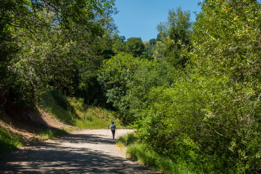
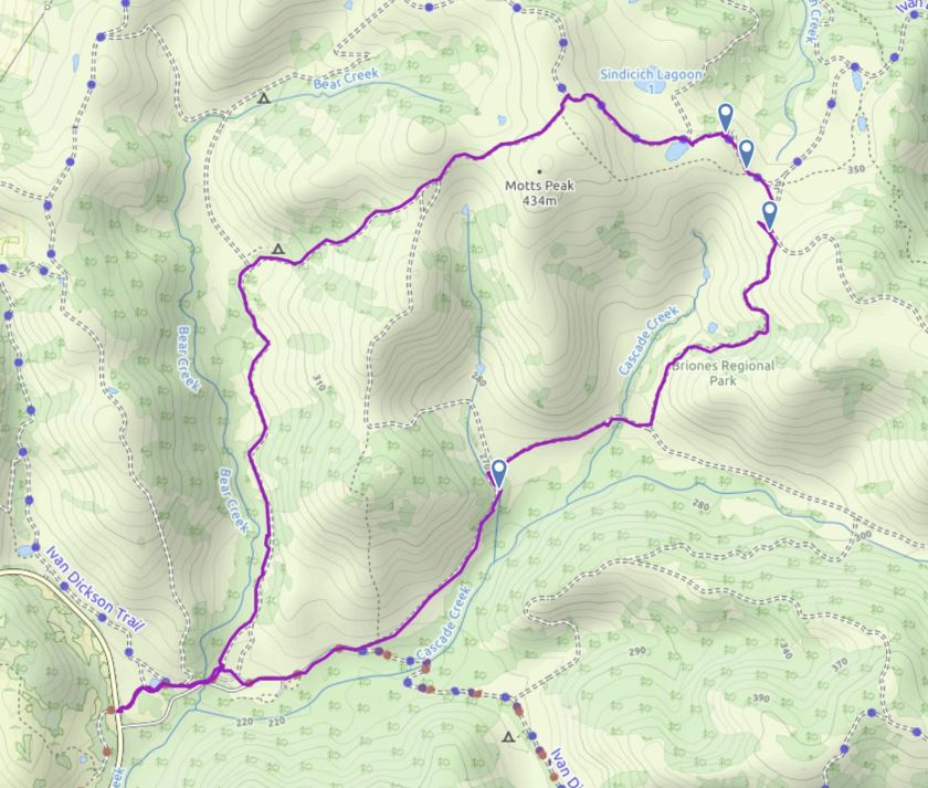
In the weeks ahead we’ll be walking about 100 miles along the Costa Brava and in the foothills of the Spanish Pyrenees. We’ll be following two self-guided tours offered through Macs Adevntures:  Foothills of the Spanish Pyrenees and Hidden Gems of the Catalan Coast. As a shakedown I decided to put a few miles on my new hiking boots so on May 12 we put the dog in the car and drove to Briones Regional Park. The goals were to give our Carson some off-leash time, log five miles and check out the wild flowers. Briones Regional Park is a 6,225-acre park in the hills of Contra Costa County. It’s about a 20 mile drive from our house. In spring it’s a stunning park with oak canyons, and green rolling hills. The ridges along the top of the hills afford wide sweeping panoramic views. Later in the year the green grass becomes a golden brown and the temperature can be quite warm.

At one point on our hike Carson decided to get a drink in one of the cattle watering troughs and ended up taking an unintentional swim. Along one of the ridges we passed a herd of cows, and Carson did his best to hike in Joann’s shadow acting a bit shy. There were a couple of steep sections of trail where I was glad I had my hiking poles, and even so, I took my time descending the steepest sections of trail.

Over the course of our walk we logged 4.9 miles. You can see a map or our course above or view more details about the track here.

On the Trail to Spain

We’ll be on the trail in Spain in June. It’s time to limber up the legs. We’ve had a very wet winter, which has kept us off the muddy trails, but with a few days of sun I decided to stretch my legs in Tilden Regional Park. It’s just three miles up the hill with 26 trails ranging from less than a mile to close to 14 miles, spread out over 2079 acres. Many of the trails are dog friendly with dogs off leash, so it’s a favorite for hiking with Carson. Tilden Park also boasts a steam train, a merry-go-round, a botanical garden and a lake to swim in. And one of the roads that transits the middle of the park closes each winter for the newt migration. The newts are not dog friendly though, they are poisonous to dogs.

In June we’ll be following two walking routes in Spain Foothills of the Spanish Pyrenees and Hidden Gems of the Catalan Coast, both walks are through Macs Adventures. In the fall of 2017 we did a walking tour of the Dordogne region of France care of Macs Adventures.

Alamo Canyon

February 3. We woke up to rain. After three nights at Twin Peaks Campground in Organ Pipe Cactus National Monument it was time to move on. Our plan for the day was to check in to the visitor center to see what the road conditions might be for the Puerto Blanco Drive, a 41 mile loop drive on a one-way dirt road. We were advised that the road might not be passable due to the rain and opted for the suggestion to drive as far as the Red Tank Trail Head and take a short hike.

When we got to the trail head, Joann set off to hike the one mile. I popped the top up on the camper and pulled out my laptop to edit photos and write. Again, with Carson, our dog, we were obligated to take turns hiking. Dogs are not allowed on the trails. When Joann returned I grabbed my rain coat and struck out on the trail hiking in the misty rain.

While I was gone, the carbon monoxide alarm in the camper decided to malfunction sending off a false alarm. The sound was too much for Carson and Joann ended up abandoning the camper and walking Carson up and down the road on a leash.

When I returned, we hit the road again, this time looking for a campsite in Alamo Canyon. Alamo Canyon is a primitive camp with four sites, first-come-first-served. We were happy to find a site open. Two of the sites were occupied with pop-up truck campers like ours, so we felt right at home.

As we were setting up camp the clouds parted and the sun shone through providing some dramatic afternoon light for some landscape photography. The next morning we took turns hiking the 1.8 mile trail up the canyon beyond the campground. More photos of the day’s adventures are available here.

Ajo Mountain Drive

February 2. Our adventures today took us through the Diablo Mountains on the Ajo Mountain Drive in the Organ Pipe Cactus National Monument. This is a scenic drive that takes you on a loop around the mountains, going up a canyon and around the rugged crags. If you have limited time in the park this is one of those must-do items. The drive is 21 miles on a one way dirt road. It’s a graded road and easily negotiable in a car although there are some very winding sections and the drive is restricted to vehicles under 25 feet in length. We used the guide book we picked up at the visitor center and we stopped at the designated locations to read about the natural history of the Sonora Desert. The guide suggests allowing two hours for the drive. We spent a good four hours, stopping to take photos and to hike. This is a spectacular drive, passing through stands of Saguaro and Organ pipe cactus and up into the rugged and mountainous terrain. The canyons with slightly higher elevation and it capture a bit more rain then the lower elevations which results in lush desert vegetation. At the top of the loop you can take a two mile round trip hike up Arch Canyon. We took turns, one of us hiking while the other kept our dog Carson company. Once again, dogs are not permitted on the trails. A number of wildflowers were in bloom including poppies. You can see additional photos of the drive here.

Organ Pipe

January 31. We arrived at Organ Pipe Cactus National Monument just as the sun was setting. Just in time to find a campsite before dark and to grab a few quick photos with my point-n-shoot Sony RX100. The photo above was taken on our third night in camp, using a Nikon D800 on a tripod. I only had to walk to the perimeter trail just east of the camp to capture this image. The Sony photos are posted below.

Not knowing what the camping situation was we decided to reserve three nights at Twin Peaks campground. Twin Peaks Campground has 34 tent-only sites and 174 RV sites. There is also a primitive camp at Alamo Canyon with four sites. More on that in a later post. It seems this time of year there are plenty of open campsites, so perhaps reservations aren’t needed. I would expect later in the season the camp may fill up. There is also dispersed camping north of the park on BLM land. We appreciated the hot showers at the camp. We’re often in primitive camps without water.

As with most national parks, dogs are not permitted on the trails, although there is a perimeter trail that loops around the camp and dogs are permitted on that trail, on a leash, as well as the trail to the visitor center. There were plenty of dogs in camp. We managed to log close to four miles with Carson just walking to the visitor center and back and around camp.

In the morning we fired up the dutch oven, Joann prepared the fixings for Hash Brown Crusted Goat Cheese and Scallion Quiche. Another recipe out of Robin Donovan’s book The Camp Dutch Oven Cookbook. We put the oven in the coals and 45 minutes later we had breakfast.

After visiting Anza Borrego, Organ pipe is a whole different experience. This is the Sonoran Desert, with it’s iconic Saguaro cactus. The Sonoran Desert is relatively frost free and it get’s a bit more water than the other deserts of the southwest. Organ Pipe National Monument boasts the highest biodiversity of any north american desert. That means there’s plenty to see in terms of both plant and animals.

Anza Borrego: Sheep Canyon

January 28 marked our first day in Anza Borrego Desert State Park, having arrived the previous evening. We thought it would be fun to take a drive up Sheep Canyon. I had been following the wildflower reports and it looked like we might find Ocotillo in bloom in the canyon. We were thinking it would be a short drive and we would be back in camp for lunch. The park maps shows the road as a “Primitive Road,” and the road was in good shape for the most part. A few miles in we stopped at Desert Garden where the ocotillo were putting on a display. The Ocotillo, Fouquieria splendens, is large shrub with long spiny stems. Like most desert plants it is uniquely adapted to heat and drought. In the heat of the summer it looks like a bunch of dead thorny sticks. Following a rain, if there is sufficient moisture it will sprout leaves., sometimes the leaves will appear within 48 hours of rain. It will then drop it’s leaves when conditions warrant conservation of water. The flowers look like flames bursting from the tips of the stems. I was happy to discover that a number of ocotillo were in bloom. Usually they bloom later in the year.

As far as Desert Garden the road is smooth and easy to manage. A few miles further we stopped to scout a stream crossing. We had some question about whether we could manage the crossing. We were informed by a woman that seemed to know the route quite well that we should have no problem with this stream crossing, as well as two additional crossings. She also told us that there was a section of road that required a good clearance and bit of rock-climbing. So undaunted we continued on. When we got to the rocky section we put the truck in four-wheel low and crawled up the rocks and continued on to the end of the road in Sheep Canyon. There we found a primitive camp with pit toilets. We had half a mind to simply pop up the camper and spend the night. It was a lovely spot with a trail heading further up the canyon into a palm grove. Dogs are not permitted on most of the trails in Anza Borrego, and since we had our dog Carson, and we had already paid for camping in the Borrego Palm Canyon Campground, we ate lunch took a walk around the bottom of the canyon and headed back down the canyon. It was late afternoon when we returned to our campsite. Like so many adventures, there’s just so much to see along the journey. You can see more photos of Sheep Canyon here.

Here’s a clip from the dashcam showing some clips we captured on the drive back down the canyon.

Surfs up on Convict Lake

I’m backtracking to December 21. The third day of my Eastern Sierra adventure. I spent a very windy night in the camper. Cozy and warm with the heater going. Outside violent gusts of wind would buffet the camper, making it rock back and forth. Reminded me of my seagoing days and recalling being seasick on a ship. Despite the wind, I manged to get a good nights sleep with my alarm going off at 6 AM. Temperature outside was 38 degrees F. My intention was to get up early to capture the early morning light on Mono Lake. Hard rain was pelting the roof of the camper, so I climbed back into my sleeping bag. At 7:30 though the light was starting to do some interesting things so I grabbed my camera headed outside. It’s common to wait for good weather to take photos. If you are looking for dramatic photos though, some interesting things can happen in a storm.

Early morning light on Mono Lake.
Clearing Storm over the Sierras. From Mono Lake

At 9:30 the sun was shining on the desert with storm clouds still clinging to the mountains. I took a short walk with Carson who was happy to roam the desert off-leash. After the walk I put the top down on the camper and headed south on Highway 395 heading for Big Pine.

Along the way I decided to stop at Convict Lake. I had been admiring photos that other photographers have been posting. A perfectly calm lake reflecting majestic mountains. Calm was not what I found. The wind was howling across the lake and through the trees, with strong gusts grabbing the tripod. I was afraid the tripod might blow over. Often times I’ll hang a weight from the tripod for stability; a bag of rocks, my day pack or some other weight. This time I opted for hand-held photos using my little Sony RX100. The articulating screen let me get the camera close to the ground to give the waves on the lake more of a sense of drama.

Windy Day at Convict Lake.

Needless to say, I think I captured an image that shows the drama of the scene.

Bodie Aborted

Returning to last weeks adventures, after leaving Emerald Bay on the morning of December December 21, I passed through South Lake Tahoe where I stopped to fill my coffee mug. Then I took Highway 207 through Kingsbury heading east to pick up Highway 395, famous for it’s scenic beauty running roughly north-south on the east side of the Sierra Nevada Mountains. When I got to Bridgeport I was intent on making a trip to the ghost town of Bodie, a former gold mining town. Several attempts to call the park for road information only resulted in a busy signal. I knew that Highway 270, the main road was closed due to snow. The park, Bodie State Historic Park, is open year round, so I thought I’d try one of the alternate routes into the park. Heading east on Aurora Canyon Road I decided to try my luck with the 17 mile drive through the Bodie Hills. A few miles into the hills the Aurora Canyon Road turns into the Bodie Masonic Road. One lane, gravel and dirt. After an hour’s driving I had logged 10 miles. The road had snow in many places but tire tracks indicated that the road had been driven recently.

It was now afternoon and as I gained elevation the snow was getting a bit deeper. I stopped for a picnic lunch and let Carson out for some well deserved off-lease time. After lunch we climbed back in the truck intent on continuing our adventure. Not far up the road though the tire tracks I was following disappeared and the grade increased a bit. The wheels were starting to slip and slide in four wheel drive as I proceeded up hill. I figured at the rate I was going it would take me another three hours to get to Bodie, if the road was even manageable. I turned around and headed back down the road. Temperatures were in the 50s, which meant the snow and ice I had been driving on was turning into slippery mud. Slipping and sliding a bit I made my way back to Bridgeport and headed south towards Mono Lake. I wanted to catch the afternoon light on the lake, weather permitting.

It was windy and chilly when I reached Mono Lake and the lighting was not as dramatic as I’ve seen on previous visits, so I left my tripod and big camera in the truck and took my trusty Sony RX100 for a few hand-held shots. I put Carson on a leash. After the walk I found a spot to camp for the night, not too far off of Highway 120, near Mono Lake.

Merry Christmas from the Alabama Hills

Merry Christmas from the Alabama Hills.

Wishing you a Merry Christmas. We are camped in the Alabama Hills in the Eastern Sierra with what appears to be an annual ritual. We were here last year. This year we represent three generations of Johnsons, the the newest addition, Annabelle, being five months old. We arrived the afternoon of Christmas Eve, set up camp, got the camp fire going along with the coals for the Dutch Oven. Dinner was Chicken Cordon Bleu, with wine to wash it down.

We were surprised by a rain storm passing through in the middle of the night, but we were snug in our beds when the sound of rain on the roof woke us. We woke to find that water that had collected in the camp chairs had frozen solid. Even so we took our time getting the campfire and Dutch Oven coals going, being torn between the photo opportunities of the early morning light and the anticipation of breakfast. Breakfast was quiche cooked in the Dutch Oven. After breakfast we poked around the hills and rocks, A cold wind was starting to find it’s way through our jackets, so we broke camp and headed back to Big Pine.

The Alabama Hills are located in the Eastern Sierra, just west of the town of Lone Pine. The Alabama Hills is managed by the U.S. Bureau of Land Management as the BLM Alabama Hills Recreation Area. There is no fee for camping and there are also not much available for services. No picnic tables, no outhouses, no water. It is also dog friendly; our two dogs were happy to wander around camp off leash. I’m always surprised to see how many people camp here over the Christmas holiday, but that said there is no shortage of spaces to camp. Last year we picked a spot that was exposed and had had a view of Mount Whitney, the tallest mountain peak in the lower 48 states. This year, with the prediction of wind we found a more protected spot with an outcrop of rocks to block the north wind.

This is a popular spot for photographers who wish to photograph the classic morning light on Mount Whitney, Lone Pine Peak and the adjacent Sierra Nevada Mountains. The granite outcroppings also provide endless opportunities for photography. This is also a popular filming location, especially Westerns. Since the 1920s, 150 movies and a dozen or so television shows have been filmed here. There are also dozens of natural arches, with one of the more popular arches being Mobius Arch. The location is also noted it’s dark skies which makes it poplular for astronomy and astro-photography. Not far the North on Highway 395 is the Manzanar National Historic Site, another location worth a visit.